-40%
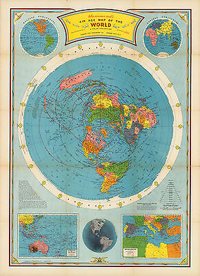
1946 Flat Earth Air Age Map of the World Azimuthal Equidistant Polar Projection
$ 6.86
- Description
- Size Guide
Description
1946 Flat Earth MapAir age map of the world. A polar projection.
Detailed Specifications
This is a reproduction of the original map
This Map Comes in Sizes:
11"x15", 16"x22" and 23"x32"
We have more
Flat Earth Maps,
you can find them in
Our Store
We have more
World
Maps, you can find them in
Our Store
All Our Maps and Posters Are Made in the USA
Azimuthal equidistant polar projection, tangent-North
Pole.
Shows naval base stations and air distances
.
Includes notes and chart for determining "Scale in statute miles along parallels
between 15 degrees of longitude."
Insets:
Western hemisphere, Eastern hemisphere, Australasia and the Far East, Mediterranean Sea, Pictorial map of western hemisphere.
This map comes with a white border around the image
---------------------------
-How are the prints shipped?
They are rolled and placed into a rigid tube.
-Is this available in a larger/smaller size.
Yes. For smaller or larger sizes, email us.


